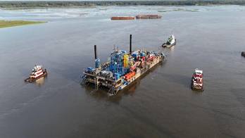

ABS Approves Seagate Space’s Modular Offshore Launch Platform
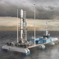
ABS has granted approval in principle (AiP) to Seagate Space for their unmanned semi-submersible launch platform – the first offshore asset to receive AiP under the newly published ABS Requirements for Offshore Spaceports.The platform, designed specifically for remote offshore launch operations and referred to as the Gateway-S, introduces a new category of modular offshore spaceport infrastructure. Gateway-S can be configured for both launch and recovery as well as disassembled into container-sized modules for transportation by sea, truck or rail, allowing for multi-site deployments.
SFL Missions Inc. Awarded Contract for Nanosatellite Development for Norwegian Maritime Monitoring System
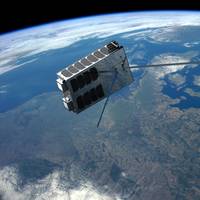
The Norwegian Space Agency (NOSA) has awarded a contract to SFL Missions Inc. to develop the AISSat-4 maritime ship tracking microsatellite for launch in less than one year. AISSat-4 is needed to expand operational capacity in Norway’s maritime situational awareness network.AISSat-4 is being developed on SFL’s SPARTAN 6U nanosatellite platform and will carry a single payload—a miniaturized Automatic Identification System (AIS) receiver built by Kongsberg Seatex of Trondheim, Norway.
Kongsberg's Motion Gyro Compasses Offer Safeguard Against GNSS Disruption
At a time when GNSS (Global Navigation Satellite System) reception face growing threats from jamming and spoofing, having a navigation system that doesn’t solely rely on satellite signals has become vital for critical maritime operations. With real-world disruptions increasingly affecting shipping and aviation safety, Kongsberg Discovery’s MGCs (Motion Gyro Compasses) deliver reliability, accuracy and resilience in contested environments. Jamming disrupts GNSS signals, limiting access to satellite-based positioning.
Satellites Help NOC Track Tidal Change for Safer Port Operations
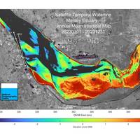
Scientists at the UK’s National Oceanography Centre (NOC) in Liverpool have used satellite data to create insight into the Mersey River that will help port operators be smarter about managing complex navigation channels. Through a project focused on Liverpool’s famous river and funded by the UK Space Agency, NOC’s scientists showed that changes in areas exposed at low tide can be mapped from space.The project, run in partnership with the Channel Coastal Observatory (CCO) and Peel Ports Group…
NOAA Satellites Helped in Rescue of 411 People in 2024
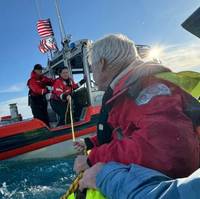
The same NOAA satellites that followed the moon’s shadow along the path of the Total Solar Eclipse and tracked Hurricanes Helene and Milton in 2024, also helped rescue 411 people from life-threatening situations in the U.S. and its surrounding waters last year.NOAA’s polar-orbiting and geostationary satellites are part of the global Search and Rescue Satellite Aided Tracking system, or COSPAS-SARSAT. The system uses a network of U.S. and international spacecraft to detect and locate distress signals sent from 406MHz emergency beacons onboard aircraft…
New Microsatellite Boosts Norwegian Maritime Monitoring
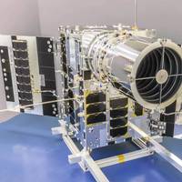
Canada’s Space Flight Laboratory (SFL) has launched Norway’s NorSat-4 maritime monitoring microsatellite.The seventh spacecraft developed for the Norwegian Space Agency (NOSA) by SFL, NorSat-4 carries a fifth-generation Automatic Identification System (AIS) ship tracking receiver and a first-of-its-kind low-light imaging camera.Built on SFL’s 35-kg DEFIANT microsatellite bus, NorSat-4 launched from Vandenberg Space Force Base in California aboard the SpaceX Transporter-12 rideshare…
Meet ‘Super GPS’: XONA Ups the Space Race Ante

With a mission to power the current and next-generation of GPS-enabled products and systems, XONA Space Systems keeps the mantra ‘precision, power and protection’ in all that it does as this 2020-start-up designs, builds and launches its fleet of low earth orbit satellites. We spoke with XONA CEO Brian Manning for his insights on how this could impact the maritime, offshore energy and subsea sectors.The following was excerpted from Maritime Reporter TV’s interview with XONA CEO Brian Manning.
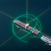
Orbcomm Wins Two U.S. Gov't Agency Contracts for Ship Tracking Services

Orbcomm Inc., a global provider of Internet of Things (IoT) solutions, has been awarded a multi-year contract by a U.S. government agency for a competitive renewal of its global Automatic Identification System (AIS) data services used for ship tracking and other maritime navigational and safety efforts. In addition, Orbcomm was awarded a separate competitive contract to deliver AIS services to multiple other U.S. government users.Orbcomm's AIS data will continue to be used in a maritime domain awareness software platform that supports key U.S.
Intellian to Launch New Factory in South Korea
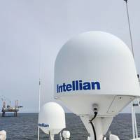
Satellite communications solutions company Intellian is set to launch another factory in Pyeongtaek, South Korea, marking an expansion of the company’s HQ base. The new factory, expected to be operational from August 2022, is located 4 km from the existing factory."The new facility and existing factory will run simultaneously, providing unparalleled production capacity of all existing product lines across maritime and land sectors, including gateway antenna systems, and the recently announced range of flat panel antennas.
Inmarsat's Satellite Services for OceanGate Expeditions' 2022 Titanic Survey Expedition
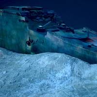
OceanGate Expeditions has announced Inmarsat as the satellite service provider for the 2022 Titanic Survey Expedition. Inmarsat’s Fleet Xpress high-speed satellite service will enable OceanGate Expeditions’ at-sea crew to instantly connect with scientific and operational resources anywhere in the world and to share important findings immediately while enhancing safety for the entire operation. Following the tragic loss of life in the sinking of Titanic, the International Convention for Safety of Life at Sea (SOLAS) was adopted.
UAF’s GINA Provides a Guiding Hand in Arctic Ocean Research
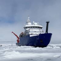
The research vessel Sikuliaq navigated among and around the chunks and slabs of Arctic sea ice above Alaska for several weeks on two voyages this fall, breaking through frozen slabs when it had to, just as its sturdy hull is designed to do. It's now on a third trip.The Sikuliaq, a 261-ft. ice-capable research vessel operated by UAF, pauses in the Arctic Ocean in June 2021 during its fifth year of operation. A few months later, it traveled farther north than ever before — almost 500 miles beyond Point Barrow.Satellite imagery produced at the Geographic Information Network of Alaska…
Communications: The Role of Secure Telecommunications in Offshore Wind Ops

While maintaining the integrity of power supply, digitalization and the integration of data have been prioritized in the energy transition process, ensuring a robust telecommunications infrastructure is essential for operational success. A well-designed and integrated telecommunications solution is critical in driving offshore wind operations and plays an integral role in connecting hundreds of physical assets and vessels. ABB Energy industries’ Ian Holden explains.Across the world and in many seas, new technologies are being harnessed to meet our power needs.
Russia Launches Satellite to Monitor Climate in Arctic
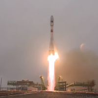
Russia launched its space satellite Arktika-M on Sunday on a mission to monitor the climate and environment in the Arctic amid a push by the Kremlin to expand the country’s activities in the region.The Arctic has warmed more than twice as fast as the global average over the last three decades and Moscow is seeking to develop the energy-rich region, investing in the Northern Sea Route for shipping across its long northern flank as ice melts.The satellite successfully reached its intended orbit after being launched from Kazakhstan’s Baikonur cosmodrome by a Soyuz rocket…